
A Wild and Wondrous Scenic Pathway from Mexico to Canada
“The world is big and I want to have a good look at it before it gets dark”.
– John Muir
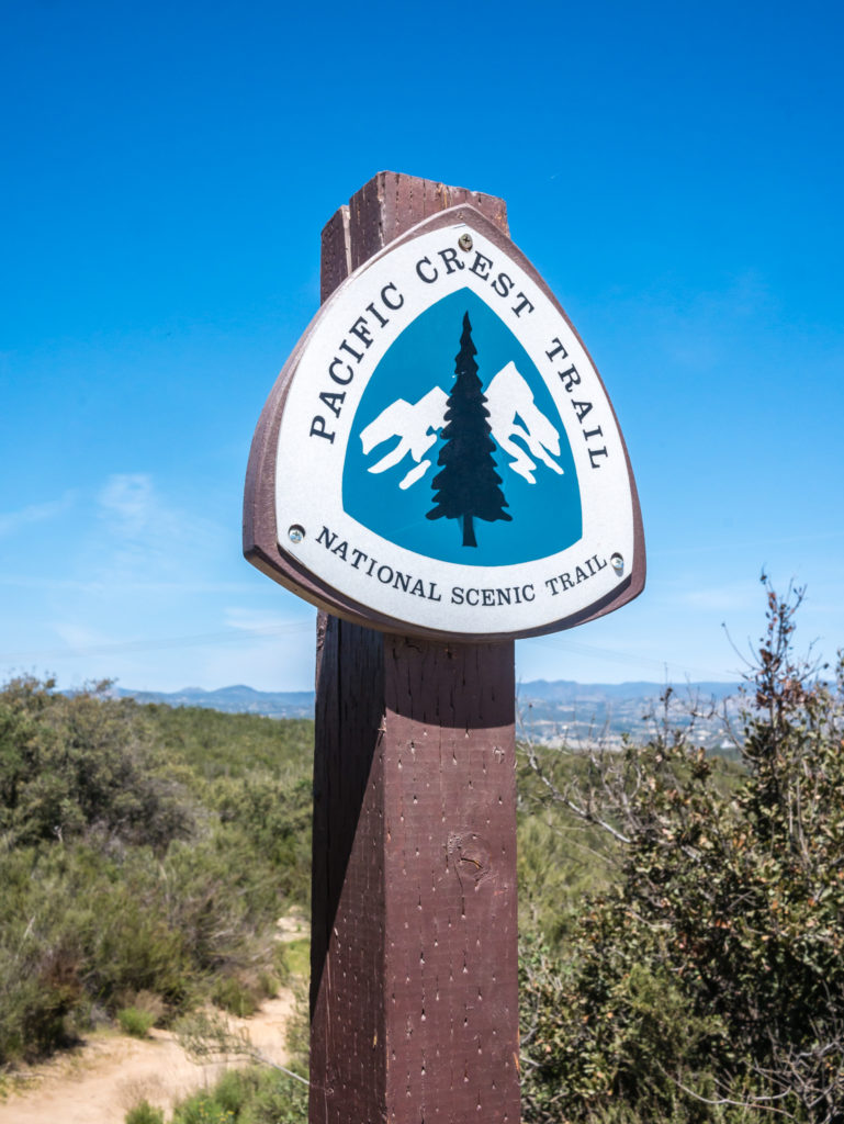
The iconic PCT marker that denotes the 2,659 mile route between Mexico and Canada.
2,659 Scenic Miles
At 2,659 miles long, (4,279 km), the Pacific Crest Trail is one of America’s ‘big three’ iconic long distance trails and the highlight of a life well lived for thousands of outdoor enthusiasts around the world. (Known together as the ‘Triple Crown’ of hiking, the other two long distance routes are the Appalachian Trail – 2,184 miles (3,515 km), between Springer Mountain in Georgia and Mount Katahdin in Maine, and the Continental Divide Trail – 3,100 miles (5,000 km), between Mexico and Canada following the Continental Divide along the Rocky Mountains and traversing Montana, Idaho, Wyoming, Colorado, and New Mexico).
The Pacific Crest Trail symbolises everything there is to love and protect in the Western United States. Walking the route, which is predominantly in the ‘wilderness’, will take you on a breathtaking journey through five national monuments, five state parks, six national parks, seven BLM field offices, 25 national forests and 48 federal wilderness areas. The PCT also crosses over 57 major mountain passes, dips into 19 major canyons and ambles past more than 1,000 lakes and tarns.
Starting In Southern California… The NOBO Route
Located in the small community of Campo, California (around 50 miles east of San Diego), and erected just a few feet away from the U.S.- Mexico border, for the majority of thru-hikers attempting the PCT, the Southern Terminus is where their journey begins. Winding northbound, the trail then passes through the three states of California, Oregon, and Washington, before it finishes on the Canadian border at Manning Provincial Park, British Columbia (some 125 miles east of Vancouver).
Crossing the San Andreas Fault and parts of the Mojave, meandering between yucca and prickly cactus, the PCT first reveals the beauty of the desert. On reaching central California, it then unfolds the glaciated expanses of the Sierra Nevada with its majestic granite mountains and countless lakes, vast meadows, alpine lichen and dense conifer forests. Northern California continues with several scenic miles travelling through lush, deep forests, whilst Oregon and Washington provide commanding vistas of volcanic peaks in the Cascade Range. Washington, being the most remote, perhaps also provides the most rugged sections of the trail, showcasing magnificent, untamed country. But be prepared – although beautiful, this section of the trail is also commonly the wettest.
What To Expect
Over the course of its length, the landscape and terrain of the PCT varies greatly, but it is designed for equestrian use as well as for hikers, so for the most part, the trail is well-graded and maintained making for a much easier walk.
In total, trail elevation gain / loss is near 315,000 feet, with the highest point of the entire route being Forester Pass at 13,153 ft, (4,009 m). In contrast, the trail’s lowest point is just 180 feet above sea level at the Columbia River Gorge between Oregon and Washington.
Like other long-distance hiking trails, the PCT is divided into separate sections. Typically, there are 18 sections in California, 6 in Oregon, and 5 in Washington (29 in total), with the average section length being 91.7 miles. On its route, temperatures can top 100ºF in the deserts, whilst dropping below freezing in the mountains.
Primarily a ‘wilderness’ trail that only occasionally touches civilisation, the philosophy of the trail is very different to that of European long-distance routes designed to pass through towns and mountain villages allowing regular access to shops and other facilities, such as evening meals and overnight accommodation provided by refuges or mountain huts. On the PCT, camping is an integral part of the experience. But what a memorable experience the trail brings, each region offering intrinsic beauties that capture the heart and soul.
Similarly, wildlife plays a significant role in day-to-day trail life. As the PCT weaves through the habitats of rattlesnakes, salamanders, eagles, roadrunners, coyotes, marmots, bear, elk, mountain goats, bobcats, cougars and other species, you must be prepared for meeting an abundance of fauna as well as flora that characterises the western United States.
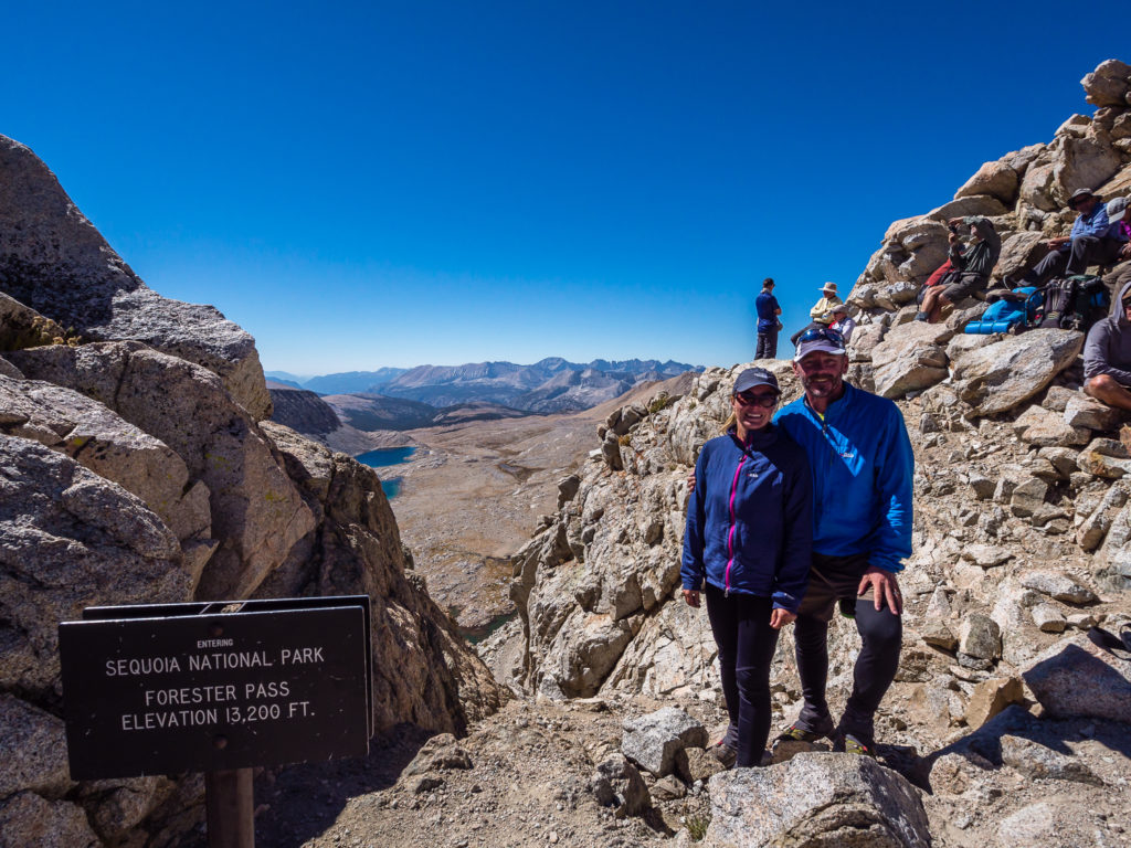
All smiles on reaching the top of Forester Pass whilst thru-hiking the John Muir Trail in 2014!
At 13,153 feet (4,009 m), Forester Pass is the tallest and most notorious point on the Pacific Crest Trail. Having reached this point before on the JMT, we have every confidence we can do it again on our upcoming hiking adventure!
History Of The Trail
The history of the Pacific Crest Trail is a long, uniquely American story marked by visionary leaders and the work of countless passionate individuals. But it was Clinton Churchill Clarke, founder of the Pasadena Playhouse and chairman of the Mountain League of Los Angeles, who is often cited as the “father” of the PCT because he organised the Pacific Crest Trail System Conference in 1932 to promote the concept of a border-to-border trail. It wasn’t then until 1968 that the PCT received official status under the National Trails System Act when it was designated a National Scenic Trail, but still the entire long distance route wasn’t officially completed until 1993.
Today, the trail is managed by the U.S. Forest Service, in partnership with the National Park Service, Bureau of Land Management, California State Parks and the Pacific Crest Trail Association. But tying the trail together is a community of volunteers and passionate outdoor enthusiasts, whom in 2010 provided in excess of 100,000 volunteer hours with the help of the American Recovery and Reinvestment Act, working to protect, preserve, and promote the trail.
How Long Will It Take?
According to the Pacific Crest Trail Association (PCTA), nearly 90% of PCT thru-hikers are NOBOs – northbound hikers, who cover the 2,659 mile distance in about 5 to 6 months. However, elite athletes who are experienced on the PCT have finished the trail in as little as two months. The superhuman few who achieve sub-100 days, hike on average well over 30 miles per day!
Long-distance hiking on the PCT should not be underestimated. Completing the entire trail in one season is undeniably a remarkable physical achievement, however amongst thru-hikers intent on this, the failure rate is high, and injuries are common. Hiking the PCT therefore requires considerable planning and preparation. It is also useful to have some back-country experience and to have put in some training miles if you really want to succeed in reaching the end.
2,659 miles is an incredibly long way and can present many difficulties if you are not prepared for what is to come. Determination and a true grit attitude can however make a huge difference to the success of your journey!
Coming from England, on arrival in San Diego, California, we had a number of final preparations to contend with before we could set foot on the trail. If you are an international traveller like ourselves, take a look at our prep post about how we got ready for 5 months in the US wilderness here.
We began our PCT thru-hike on 10th April 2018 and finished 166 days later on the 23rd September 2018. Our PCT trip reports are posted below. We hope you enjoy following along with our journey on foot from Mexico to Canada!
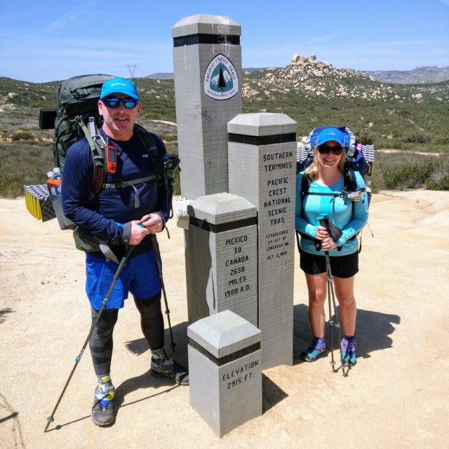
Starting at the PCT Southern Terminus at Campo on the border with Mexico.
It’s official! We started hiking the PCT on Tuesday 10th April, 2018.

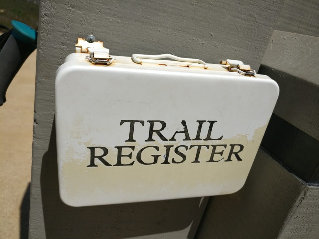
Signing the trail register. ‘Footsteps and photographs here we come!’
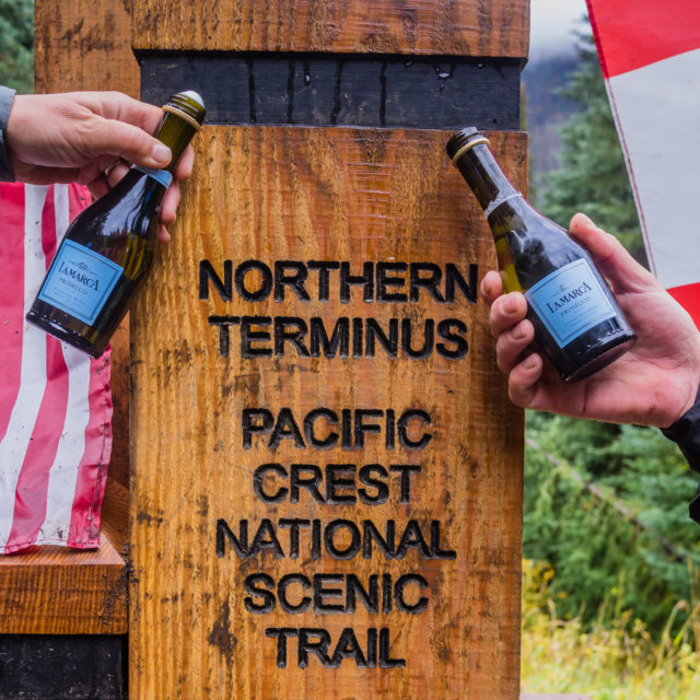
After 166 days… We made it to the Northern Terminus and the Canadian border!
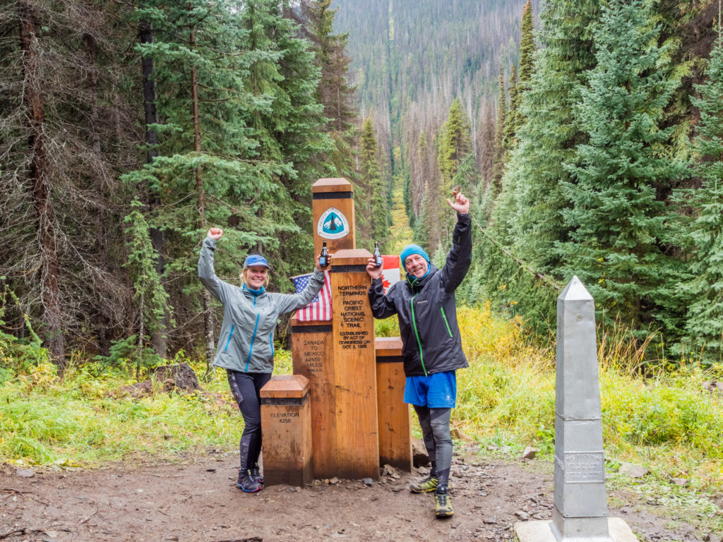
Celebrations at Monument 78!
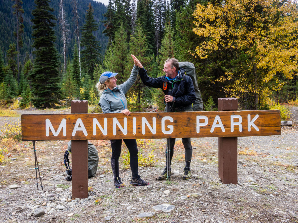
Crossing the border into Canada and walking the remaining 8 miles to Manning Park. 2,659 miles – job done!
Hiking The PCT, Week 23, Northbound To Mile 2,549 – The Twenty-Third Week – A Race Against The Snow!